Pages

Sunday, June 30, 2013

East Dix (Grace) to Elizabethtown #4 - 6/30/13

Today's hike was a comedy of errors.  Every once in a while it is like that.  More on this later.  First of all, the trip plan was to start from Route 73 south of Keene Valley and hike the herd path to the East Dix slide.  Then I would climb the slide and follow the ridge from East Dix down past Spotted Mountain and Elizabethtown #4, then drop back down to the South Branch Boquet River and retrace my steps out.

I packed my things this morning and put all my drinks in my cooler to keep them cold as long as possible.  After that, I was on the road.  Ten minutes later, I got a call from my wife, Leesa, informing me that I left the cooler at home.  Back I went.  All my water bottles were in the cooler.  Had to go back.

Next I got to my parking location and started my hike.  Again, 10 minutes later, I realized I didn't take the drinks from the cooler and put them in my pack!  You can tell I was just excited to get hiking.  The problem is that I'm not used  to using a cooler, but now that it's hot, the cooler is in use.  Now it was 9:30.

Back on the trail I went.  Usually I just stay on the south side of the North Boquet as I hike in.  This time I would have preferred the more defined herd path that crosses to the north side of the Boquet about 10 minutes into the hike, but with the heavy rains of the past couple days, the water was high.  It didn't look like a good option,  especially since I had my dog Rev with me.

Therefore, I stuck to my usual route.  I was at Lilypad Pond in 30 minutes.  I continued on and reached the final designated campsite in about 90 minutes.  It is a large site located between the S. Branch Boquet River and a tributary that comes from near the Beckhorn Slide.  I saw a backpack hanging high in a tree near the 1st waterfall on the Beckhorn tributary.


Last designated campsite.  About 3.6 miles from Route 73. 


I continued on by following the herd path past the cairn located at the back of the campsite.  Just upstream on the Boquet from the campsite is a nice swimming location.  I passed that and kept going.  I was surprised throughout the walk along the Boquet that the water had breached the banks in many locations in the past 2 days of heavy rain.   

     
Cairn at the campsite


Waterfall on the Beckhorn tributary

I passed one more campsite just before the trail started climbing towards the slides, but I think it might be an illegal site and it is located adjacent to to the trail on the left.  Immediately after that, I found a set of cookware in the trail.  I left it there, not knowing why it was there. 


Giant and RPR in the background


When the herd path came to the base of the East Dix slide, I noticed that the slide was almost entirely wet.  I saw a cairn indicating it was time to step out onto the slide.  I thought that perhaps it would be better to follow the herd path a little further and then step out onto the slide up higher where the rock would be dry.


Near the base of the East Dix slide.  A small cairn marks the way


Take note... the herd path doesn't run parallel to the slide after that location.  It veers towards the East Dix/South Dix col.  By the time I realized it, I decided it wouldn't be worth while to try to cut back over.  In minutes, I was on the ridge herd path. I turned left to head towards East Dix and was on the summit in 5 minutes.    

Looking SE from East Dix


It had taken me about 3.5 hours to reach East Dix via my route.  I stopped on the summit to have lunch.  Afterwards I began working my way down the ridge.  I had previously climbed Spotted Mountain, but I had never climbed the stretch between East Dix (Grace) and Spotted.


Summit disc


Below are a bunch of pictures from the ridge as I headed down.  I actually think the ridge gets better as you get lower.  Spotted Mountain and Elizabethtown #4 are especially nice.  The entire ridge offers lots of open rock, mixed in with some bushwhacking.  It is thick in some spots.  Faint herd paths can be found, but they are hard to stay on. 


Looking SE again


Looking N towards Spotted Mountain.  Giant and RPR in the background.


Climbing SW Spotted


A glacial erratic along the way


Looking back towards East Dix


Hough and Dix Mountains in the background


Elizabethtown #4 with Giant and RPR behind


Once I got to Elizabethtown #4, I just headed slightly west of north to return to the herd path on the S. Branch Boquet River.  After another hour I was back at the car.  The entire trip took about 8 hours.  It really is a nice mix of following a stream (on a herd path), then the slide, then ridge walking (with open rock and bushwhack), then hardwoods back to the river and out.

As I drove home, rain started in about 30 minutes.  My timing was good.  


Rain coming in


My route (Click image to enlarge)

Hike Details:
Hike Distance:  11.6 miles
Hike Time:  8 hours, including stops
Total Vertical Gain:  ~ 3500'  

Friday, June 28, 2013

Flowed Lands from Upper Works - 6/23/13

This was a hike into Flowed Lands from Upper Works to check on our adopted lean-to, Herbert Brook.
The weather was questionable with scattered showers in the forecast, but Leesa and I weren't going above treeline so we weren't too concerned.

The Calamity Brook Trail was wet and muddy, but we just took our time managed to get through it OK.  On this day, we took 2 hours to reach Flowed Lands.  It takes 1.5 hours when we are moving fast.

I like the Calamity Brook Trail, in spite of it's mud.  It also has a fair amount of rocks to negotiate on the trail, but I like the variety of woods.  In the winter, it is without a doubt, one of my favorite ski trails.


Flowed Lands amid the threatening clouds


On the hike in, I was telling Leesa that it is kind of fun getting caught in a rainstorm while you are at a lean-to. As luck would have it, that is exactly what happened.  We arrived at the lean-to and looked things over and just as we were sitting down to have lunch, the sky opened up.  


... the rain is arriving

... no doubt

It only rained for about 10 minutes, but it was enough to bring the bugs out.


Watching the rain fall...


Rev wasn't watching the rain... just the food


...almost ready to clear


...the sun is ready to come back out


interesting skies after the rain stopped


another look

As soon as the rain stopped, the black flies found us at the lean-to.  It was enough to get us headed back.


The route from Upper Works to the Herbert Brook lean-to and back is about 11 miles round trip.  It takes us anywhere from 4 to 5.5 hours to do the trip depending on how fast we're moving.  

Flowed Lands, Lake Colden and Avalanche Pass are nice areas to explore.  Not every trip has to hit a summit.

A snapping turtle on Tahawus Road near where the train tracks cross


Our route (Click image to enlarge)

Hike Stats:
Hike Distance:   ~ 11 miles
Hike Time:  6 hours (including stops)
Total Vertical Gain:  ~ 1500' 


"Hill 864" - Dix Mountain Wilderness - 8/15/13

The Boquet River Valley in the Dix Mountain Wilderness of the Adirondack Park can provide almost limitless places for exploration.  For my wife and I, It's a convenient place to get to and it's a whole lot of fun.  On this trip, Leesa and I wanted to head for an unmamed hill, labeled on our map with an elevation of 864 meters. 

To head there, we parked on Route 73 and followed a herd path on the south side of the North Branch Boquet River.  Once we got to LilyPad Pond, we crossed a tributary and hooked back to the N. Branch (it had turned NW a little earlier). 

The herd path grew faint on the west side of the North Branch as we made our way NW.  Right at that point, we found a little knoll with a fire ring.


A fire ring near the N. Branch Boquet River
 

There was also a couple great swimming holes at that point.  Most of the water pictures below were taken at that point.  Shortly afterwards we came to a wetland area and it was time to veer more to the NW and start climbing the hill.
 
 
It was a hot day and the deer flies found us.  It helped a little having the leaves on the trees.  Bushwhacking through the trees made it hard for the deer flies to stay with us.


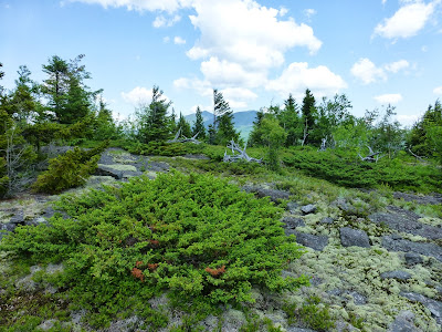
After a hour or so on the bushwhack portion of the hike we came to the first false summit at elevation 774 meters.  It was an area of open rock that afforded nice views of Elizabethtown #4, Spotted Mountain and Grace.
 

View from hill 774.  Spotted Ridge on left.  Beckhorn Slide on right
 
We stopped here to have lunch.  Afterwards we contemplated going further, but Leesa had had enough of the bugs for one day.  We looped around to descend on the other flank of the ridge before returning our route near the swimming holes.


A good view of the Beckhorn slide.


Fun water holes for swimming.
 
Large glacier erratics at the water's edge


Snack time

Back at the swimming hole we took off our boots and soaked our feet.  The water was still a bit cold for swimming.  We also had a few snacks and explored around the area.  The location of the swimming holes is identified with a dot on the route map at the end of this post.


Once back across the tributary and over to Lilypad Pond, we went back along the south side of the N. Branch Boquet River.  There isn't much of a herd path there until you get to the designated campsite on the knoll.  From there, you can follow the herd path back, or the other one to Rhododendren Pond.
  

We just went back at that point.  Can't wait to swim in the swimming holes though!
 
Map of our route (Click image to enlarge)
  
 
...and a closer look
 
Hike Stats:
Hike Distance:  7.75 miles
Hike Time:  6 hours (including stops)
Total Vertical Gain:  ~ 1500'


Friday, June 14, 2013

"The Three Gems" Tribute Hike - Dix Mountain Wilderness - 6/14/13

Today's hike was first and foremost a tribute hike.  Lt. Col. Todd Clark was tragically killed in Afghanistan on Saturday June 8th.  He and 2 others were killed on that day. 
Today was the ideal day to do this hike.  Flags in New York State were at half mast today in honor of the fallen soldiers.  We have our freedom because of soldiers such as Lt. Col. Clark.
 My destination was 3 small peaks known by some on the ADK High Peaks Forum as "The Three Gems".  They lie just east and northeast of Spotted Mountain in the Dix Mountain Wilderness Area of the Adirondack Park.  I had not climbed these hills before.
 I started on Route 73 and headed SW following a herd path just south of the South Branch of the Boquet River.  After 2 miles, I passed a designated campsite and knew it was time to turn SE and climb the first of the Gems.  Once on the First Gem, I again worked my way SW onward and upward; each Gem being higher than the last.  All three have fine open rock summits, but the southern most highest Gem by far has the best views.
 

Looking at the summit of "Clark Peak"

I decided that I would call this peak, Clark Peak, in honor of Lt. Col. Clark.  I said a prayer for him, his family, and the others killed last Saturday.  I will always think of this peak as "Clark Peak".  He would have deserved as much.


A closer look.  Noonmark, Round, Giant and Rocky Peak in the background.
   

Rev liked it here!
 
She's contemplating

 
Another look at Noonmark, Round, Giant and Rocky Peak 
  

Looking South
   
More of the summit

Walking around the summit I came across a nice 4 point deer antler.  I kept looking around and soon found the other one!  I've never found a pair before; always just one.  It made me wonder if by any chance, Lt. Col. Clark was a deer hunter.
 
   
I found a pair of antlers on the summit!
 
Looking at Wyman, Elizabethtown #4,  SW Spotted and Spotted
 
Coming down off the summit of Clark Peak
  
I don't know what these are, but they are pretty and they were growing near the summit
  
I spent an hour on the summit before heading down.  I crossed an unnamed feeder to the South Branch Boquet River.  Soon I came to the South Branch itself and followed it upstream, heading NW.  Eventually I turned N-NE to head for Lilypad Pond.
 

An unnamed feeder for the S. Branch Boquet River
 
 After Lilypad Pond, I followed the N. Branch Boquet River before turning SE to go to Rhododendron Pond. 
  
North Branch Boquet River
 
Rev in the N. Branch Boquet River

After Rhododendron Pond, I went east then NE to return to Route 73 and back to the car.  At this point I was getting attacked by a few persistent deerflies.  They are never pleasant.
 

Wild Iris at Rhododendron Pond
 

A beaver double effort at Rhododendron Pond 
 
I felt good about doing this hike and dedicating it, along with the beautiful 3rd Gem hill to Lt. Col. Clark as Clark Peak in my mind.  May he rest in peace.  I thank him for his outstanding service to our country.


A map of the hike (Click image to enlarge)
 
 
Hike Stats:
Hike Distance:  10 miles
Hike Time:  7.75 hours, including stops
Total Vertical Gain:  2300'